Google Earth is offering a 3D representation of the wedding route, giving people the chance to pick the perfect spot on London’s streets to observe the wedding procession and the happy couple.
For many visitors, both foreign and domestic, London can present a formidable navigational challenge. And with an influx of people travelling to the capital city to catch a glimpse of Prince William and Kate Middleton, the 3D virtual tour from Google Earth should provide some assistance.
Essentially, Google Earth provides a detailed view of the key locations along the London procession route for the wedding day.
Google Earth recently added a number of tours to key popular European destinations, which contain detailed 3D photographic scenes of the locations.
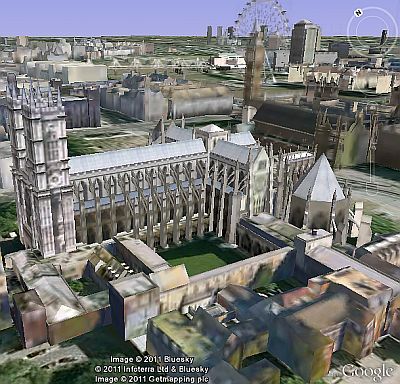
The wedding route begins at the wedding location, namely Westminster Abbey, which has been the traditional location for royal coronations and weddings for hundreds of years.
The Google Earth tour then shows Parliament Square, Whitehall, the Cenataph and Downing Street.
And of course the final stretch from Horse Guards Parade through St James Park to Buckingham Palace.
Users can rotate, zoom in and out, and gain a bird’s eye route of the route, and can even opt to ‘walk about’ the street view of the location.
Users will need to download a Google Earth plug-in, available here.
Thoma Bravo agrees to acquire Darktrace for $5.32 billion in cash, delivering some welcome news…
Customer adoption of AI services embedded in cloud services continues to deliver results for Microsoft,…
TikTok's 'secret source' algorithm is so core to ByteDance, it would rather shut down US…
After relocating from California to Texas in 2020, Oracle's Larry Ellison now reveals plan to…
Share price hit after Meta admits heavy AI spending plans, after posting strong first quarter…
For third time Google delays phase-out of third-party Chrome cookies after pushback from industry and…
View Comments
I Love T
absoutley rubbish