Google Releases Street View Images Of New Orleans Reconstruction

Google has updated its Street View images of New Orleans portraying the city’s efforts to rebuild seven years after Hurricane Katrina
Almost seven years after Hurricane Katrina devastated New Orleans and much of the Gulf Coast on 29 August, 2005, new images of the recovery and continued rebuilding have been posted by Google Street View as part of its work to bring fresh images to its extensive map operations.
The new set of powerful images “helps show the rest of the world that New Orleans, and all of Louisiana, are not just rebuilding what was, but we’re also preparing for our future by building back stronger and better than before,” wrote Mitch Landrieu, the mayor of the city of New Orleans, in a guest post on 14 August on Google’s Lat Long Blog.
First update since 2008
It’s the first time that Google has updated the Street View images of the city since 2008, when the photographs still communicated the destruction that occurred all over the area due to Katrina’s Category 3 winds. Landrieu was Louisiana’s Lieutenant Governor when those first images were posted, and he wrote about those first pictures in a Google post at the time.
 “New Orleans is a uniquely American city,” wrote Landrieu. “It’s a place with indigenous culture, heart, and soul with our own music, cuisine, and architecture. You can really see and feel its originality and personality walking around our historic streets.”
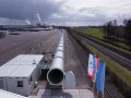
The latest images published this week, including photographs of Lafayette Square, Tulane University, Louis Armstrong Park and the Mercedes-Benz Superdome, “more accurately reflects the major construction and renewal that’s under way” in the last several years, wrote Landrieu. “It’s everywhere you look, from the nearly 2-mile long, 26-foot-high Inner Harbor Navigation Canal (IHNC) Hurricane Protection Barrier to the major construction near downtown that will be the future site of two hospitals and a biomedical research corridor.”
The photographs portray the “major investment being made to revitalise playgrounds, community centres, roads, and parks, like historic Congo Square in Armstrong Park – the ‘birthplace of jazz’,” he wrote.
“New Orleans is now a hub of entrepreneurship and innovation, and it was found to be the fastest-growing city in America by the US Census,” wrote Landrieu. “We are hard at work physically rebuilding schools, improving what happens inside the classroom to close the achievement gap for inner city youth, and making progress on education reform.”
Progress
The new images will let viewers “see, appreciate, and celebrate the progress in neighborhoods here in New Orleans and across the entire state”, wrote Landrieu. “And I welcome you to come experience the sights, sounds, and soul of New Orleans for yourself once you’ve gotten a virtual preview to whet your appetite.”
Even the unofficial Google Maps Mania blog got into the act upon the news of the fresh New Orleans Street View images, publishing its own collection of photographs from the collection.
Another blog, “Update Google Street View in New Orleans!”, was created after its creators repeatedly had been asking Google for new updated images of the city since the first images were posted by Street View in 2008. That site, too, has collections of many photos of the city post-Katrina as the clean-up and restoration has continued.
The powerful hurricane pounded New Orleans and much of the Gulf Coast, taking out utilities, water supplies, normal municipal services and lots of other critical infrastructure that in many cases took months or years to return.
How well do you know your webcam? Take our quiz.