Energy Leaks Detected By Thermal ‘Sniffer’ Cars

Cars equipped with thermal-imaging equipment can now detect energy leaks of buildings and homes
A bulk energy audit of all the homes and buildings in an entire neighbourhood is now a reality after a startup in the US revealed how its thermal-imaging equipped cars can detect energy leaks on mass.
The company is called Essess and its technology was developed in the Field Intelligence Lab at the Massachusetts Institute of Technology (MIT). The firm aims its technology at electric and gas utilities to help them meet energy efficiency goals.
Thermal Maps
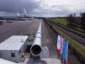
The idea is that utility companies can hire Essess’s thermal-imaging cars that will be able to map out an area in a quick ‘drive-by’, tracking the energy-leaks of thousands of buildings and homes. Previously, this technology was often carried out by individual person on a single building or home, using a handheld thermal camera.
Now whole neighbourhoods can be quickly mapped by a utility, who can then dispatch the information homeowners or building owners to facilitate structural improvements to their structures in a scalable and cost-effective manner..
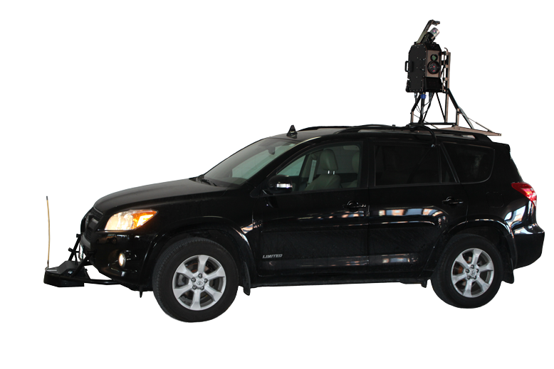 Like the famous Street View cars that Google deployed worldwide in 2007 with a 360 camera on its roof, the Essess car also has a rooftop rig the size of a large backpack that allows the company to create heat maps of buildings. The rig includes a number of long-wave infrared radiometric cameras and near-infrared cameras. These cameras capture heat signatures, while a LiDAR system captures 3D images to discern building facades from the physical environment.
An onboard control system has software to track the route and manage the cameras.
“We’ve made thermal imaging very automated on a very large scale,” Essess co-founder Sanjay Sarma was quoted as saying by MIT News. “I remember thinking, ‘Wouldn’t it be easier to just throw it on a car and drive by the house?’”
But it seems that while the idea was good, there were challenges. “Very expensive thermal cameras had lower resolution than your smartphone camera,” Sarma was quoted as saying, and pointed out that such cameras used to cost about $40,000 (£26,428).
But in 2011, an MIT student made a number of innovations to the rig that allowed low-cost cameras (about $1,000) to produce high-resolution thermal images. Among other things, this included an algorithm called Kinetic Super Resolution that computationally combines many different images taken with an inexpensive low-resolution infrared camera to produce a high-resolution mosaic image.
It is thought that Essses has so far mapped more than 4 million homes and buildings in cities across the United States. It works with government and state institutions to help them identify energy-wasting buildings.
Fly-By Map
A similar option is already available in the UK. In early 2013 aerial mapping company Bluesky created an online map which showed heat loss from individual homes in Portsmouth. It gathered the data from a plane equipped with thermal sensors, to map the temperature of buildings in the city on a cold winter night.
That visual display allowed businesses and residents search for their address and see its thermal properties. Each building’s image was matched to address data to allow a postcode search.
At this year’s CES show, Oregon-based FLIR claims to offer affordable thermal imaging technology to consumers for the first time. A case for the iPhone turns the smartphone into a heat-detecting tool.
Are you a real green expert? Try our quiz!